Using a phone to get around a city can be challenging. Tall buildings block and bounce signals, which can lead to wrong turns and maps that aren’t right. This phenomenon is a big problem for navigation systems today. As 5G networks become more common, they may help resolve this problem. These revolutionary networks do more than just give you quick internet. Their design could give phones new tools to find places much more accurately in hard-to-navigate city areas.
The future of finding your way with 5G
GNSS is the most common navigation technology in phones, but it doesn’t work well where people need it most. Skyscrapers in the middle of cities can block or reflect satellite signals. This causes your location to jump across streets or paths in the wrong way.
Researchers are now developing new ways to fix this. They use various satellite data and detailed 3D city maps. They want to build a positioning system that is always on and works better. This is a major step forward for the future of city services and transportation that use 5G technology.

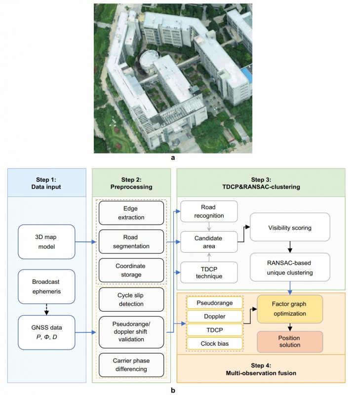
In complicated urban settings, current methods often don’t work. They depend on ideas that don’t work with tall buildings. A group of Chinese researchers has developed a new framework. They combine map data with special satellite measurements in their method. This includes signals that keep track of short-term movement. Their new system considers both the layout of buildings and the direction of motion to determine where to place things. The system reduces positioning mistakes significantly.
The technical core of this method is a “factor graph optimization” framework. It combines different types of data over time in a smart way. First, a probabilistic model searches for the street segment most likely to match your location. Then, a grouping method selects the best location solution from the group. The optimization engine receives all of this data. The system measures the pseudorange, the Doppler shift, and the time-differenced carrier phase. This process makes a smooth, accurate path even when the signal is very weak.
Testing in a crowded campus setting produced excellent outcomes. In more than 93% of cases, the new strategy had positioning errors of less than 5 meters. Such performance is a big step up from the advanced fusion methods already available. The paths that emerged were smoother and aligned correctly with the real walkways. This big jump in performance comes from using high-precision data that phones don’t always use. The framework establishes a connection between precise short-term movement and absolute position.
The infrastructure for 5G will be crucial in the future. Better predictions will be possible with more detailed 3D city models. We also need reliable ways to correct signal drops on 5G networks. This GNSS method could be extended to work with other smartphone sensors in the future. You could add LiDAR, cameras, or inertial measurement units to the framework. This mix of sensors would keep things accurate even if all the satellites went down.
In conclusion, this study is a significant advancement in choosing the ideal location in urban areas. It uses 3D maps and sophisticated signal processing to solve the most significant issues with existing technology. These technologies must be compatible with the growing 5G networks. This collaboration will help develop the next generation of navigation tools, enhance location-based services, and make cities smarter. Finally, we will resolve the annoying issue of losing GPS signal in a city.